The Global Wildfire Information System (GWIS) is a joint initiative of the GEO and the Copernicus Work Programs. In the GEO GWIS work program for the years 2023-2025, GWIS aims at bringing together existing information sources at regional and national levels in order to provide a comprehensive view and evaluation of fire regimes and fire effects at global level; the fires mapped in GWIS may include fires set intentially for the purpose of vegetation management. Additionally, GWIS provides tools to support operational wildfire management from national to global scales.
GWIS builds on the ongoing activities of the European Forest Fire Information System (EFFIS), the Global Terrestrial Observing System (GTOS) Global Observation of Forest Cover- Global Observation of Land Dynamics (GOFC-GOLD) Fire Implementation Team (GOFC Fire IT), and the associated Regional Networks, complementing existing activities that are on-going around the world with respect to wildfire information gathering. The development of GWIS is supported by the partner organizations and space agencies, while its main funding is provided by the European Commission. Support to GWIS was provided by NASA through its GEO-GWIS activities in the ROSES program .
Currently, GWIS is made of five applications:


The European Union and the countries of Latin America and the Caribbean (LAC) are collaborating in the project Support to Forest Fire Management in Latin America and the Caribbean, an initiative that aims to improve national capacities to prevent forest fires from a regional perspective, relying on EU best practices: the European Forest Fire Information System (EFFIS) and the European Group on Forest Fires (EGFF).
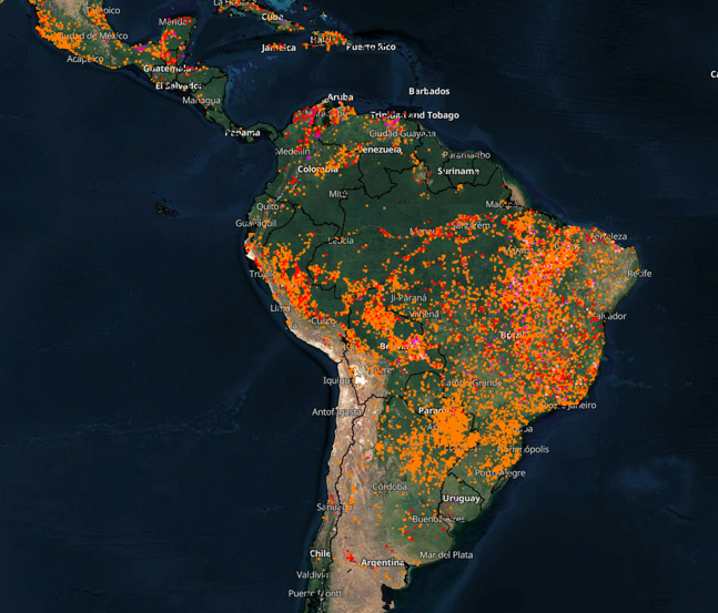
In this initiative, cooperation between country experts has been and is key to develop effective measures in all phases of fire management and monitoring.The project is implemented on a regional scale through two programmes:
- FPI Programme: 2020-2023
- Amazonia Plus Programme: 2023-2027